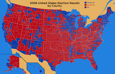
Contrary to popular opinion, the U.S. is not a nation of red states and blue states (and in case you just arrived from another planet, red means Republican and blue means Democrat). Far from it, except in the states of Vermont, New Hampshire, Massachusetts, Connecticut, Rhode Island, and Hawaii (where Democrats carried every county), and Oklahoma (where Republicans carried every county). In the other 43 states, when viewed county by county, we are a crazy quilt of red splotches and blue splotches. What we are, basically, is a nation of red counties and blue counties. Click on the following map to get a better look.

A close examination of the 2008 presidential election map, coupled with a geographer’s eye for where the major metropolitan areas are, reveals that people living in cities and suburbs tended to vote Democratic (blue), except where they didn’t, and people living in rural areas tended to vote Republican (red), except where they didn’t.
Next time, just to be different, I’m hoping they’ll use purple and green.
purple and green aren't going to change anything...my vote will still never count since i am surrounded by mauve or pinktruse or whatever you chhose to surround me around with...i am definetly going to move to boston,,,,they are my kind of people not bumbling farmer bumkins in utar
ReplyDeleteThis was interesting. Just goes to show how scale can change statistics.
ReplyDeleteVery interesting, indeed!
ReplyDeleteA different presidential Election Map allows you to see exactly how and why the election played out the way it did. This map ignores land mass in favor of one dimension only – how many people live in each state.
ReplyDeleteThe Newman cartograms were computer generated. ODT’s map was created and drawn by former Chicago Tribune cartographer, Paul Breding. On Breding’s map each of the map’s grid squares represents 250,000 people. On the map is the exact population of the larger states along with each state’s electoral votes. The bigger the state on this map, the greater the electoral clout. This type of map demonstrates the power & importance of the toss-up states. See article at http://www10.giscafe.com/nbc/articles/view_article.php?articleid=601182 Map and images are at: http://odtmaps.com/detail.asp_Q_product_id_E_pres-map-2008 GIF files from ODTmaps.com are downloadable and free for any personal/non-profit use of the maps.
It's hard to believe that with THAT much RED we now have a BLUE President...things that make you go hmmmmmm...
ReplyDeleteThanks to the following for commenting:
ReplyDeletePutz - Yes, but if you moved to Boston you'd sound like Teddy Kennedy.
Ruth - I agree. Someone (Disraeli, maybe?) said, "There are lies, damned lies, and statistics."
Pat - Glad you found it interesting! I hope Mr. Lincoln is doing better.
BAbramms - I started to use one of those maps, but I didn't like the way it distorted our geography.
Angela, if acreage voted, we would definitely have a blue president. But people, not acreage, do the voting, and there are a lot more people per acre in New York and Chicago and Los Angeles than in, say, Kansas or Wyoming or Utah.
As a former Texan, one thing I found interesting is that in my old stomping grounds (the "Megaplex"), Dallas is blue and Fort Worth is red. I've always thought those two cities were back to back, not facing each other at all.
Correction! Acreage = RED president. People = Blue.
ReplyDeleteInteresting map! It appears I live in one of those "except where they didn't" blue areas. In fact, all of northeast Iowa is that way. We must think like city people here.
ReplyDeletePutz sounds like an angry person.
ReplyDeleteThanks for even more comments!
ReplyDeleteJeannelle, either that or city people think like dairy farmers.
Sam, Putz is an ordinary person, I think, not the type who can go deep-sea fishing off the coast of Baja California. :)